 Placer County Water Agency workers began a routine "black start" drill at Oxbow Powerhouse near Ralston Dam on the Middle Fork American River. They were simulating a power outage in order to assess the Powerhouse's ability to operate under such circumstances. It appears as if this drill prompted one and a half gates at Ralston Dam to open, spilling 1,000 acre feet of water into the Middle Fork.
The malfunction went unnoticed for nearly an hour until an alarm in the Powerhouse alerted personnel that the reservoir that feeds Ralston was dropping rapidly. Agency workers rushed down to the dam to close the gates manually.
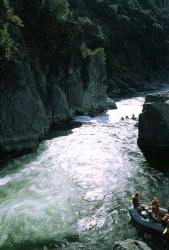
Meanwhile, halfway down the river canyon, ten AO guests accompanied by three AO guides were just waking up from a beautiful night spent under the stars. The guides were preparing to cook breakfast when they heard a strange sound--like a strong wind whipping through trees. Then they noticed the water rising. Their first thought was that it was a bit early for the water to be coming up (flows ramp down in the late afternoon because the dam stops releasing water; when more water is released the next morning, it usually takes several hours for the flow to reach the AO camp area). Their next thought was that the water was rising very quickly. Too quickly.
Moving fast, the guides moved the rafts and camping equipment to higher ground. However, the water kept advancing and the equipment had to be moved several times. Ultimately, everything had to be moved to the top of camping area. By this time, the space that not long ago housed their kitchen was under several inches of water.
Just as quickly as it advanced the water began to recede. At this point, State Parks helicopters were buzzing the canyon, yelling through megaphones to get to high ground. But the guides, who were then cooking breakfast in their new high perch above the river, saw the receding water lines and realized they'd better get on the water in case flows dropped below a navigable level.
Turns out they were right. Soon the river flow dissipated to a paltry 300 cubic feet second--what's called "fish flow"--an un-navigable level. But not before the All-Outdoors trip made it down to an early take-out point.
By the time the morning was over, the river had rose to 5,666 cubic feet per second--more than five times its normal summer flow. Though media outlets reported that the water appeared as a 4-foot wall of water, AO guides say there was no "wall of water"; the water simply rose very quickly.
So far the consequences of the flooding seem to be minimal: there is a new, fun hydraulic in Santa's Moustache Rapid, a large tree lodged at the North Fork/Middle Fork confluence, and Lettuce Hole Rapid downgraded from a Class IV rapid to a Class III because of rock movement.
Placer County Water Agency officials are still investigating the malfunction. The offending gates will remain closed until they've discovered what caused the problem. Water flows on the Middle Fork American are back to normal levels.
To come see the effects of the flooding yourself, visit the Middle Fork of the American.